Text and photos by Kunal Pathak - Loss Prevention Manager of Gard, Singapore
In a navigation incident, the first line of inquiry would normally cover the bridge watchkeepers. While the human element plays a significant role in these incidents, it is perhaps worth asking, what if some geographic areas are more prone to navigation incidents than others?
The majority of the investigation reports tend to conclude that “human error” is the root cause of navigation incidents. Among the findings, human error generally entails; lack of situational awareness, poor lookout and competence of the mariners involved. The human error, as has been observed in several investigation reports, may well be just one of many factors contributing to the incident. There may be other factors which may not have been paid attention to during an investigation, such as geographic areas of high frequency of navigation incidents, or “navigation hot spots”.
This article will focus on our work with data on vessels movements where we look at a possible different narrative for navigation incidents. We will firstly evaluate data collected on all navigation incidents for the five year period of 2016 to 2020 to understand how geographical locations compare for collisions and groundings. Contact incidents, i.e. allisions with fixed objects, are omitted as most allisions are related to navigation during berthing/un-berthing operations. They can be complex to evaluate and do not fit the scope of this article.
Secondly, we will focus on contributing factors that lead to these incidents. Instead of human errors, we will focus on vessel behaviour. One could argue that the vessel behaviour is also linked to the humans operating the vessel, but when we look at these behaviours, we may be able to see a different pattern providing another perspective.
Before looking at our detailed analysis, we will take a look at Gard’s claims data to understand the scale of the issue.
Navigation claims in Gard
Looking at Gard’s hull & machinery claims data for the 2016 to 2020 policy years, we see a 15% increase in the number of registered navigation claims in the Gard hull & machinery portfolio. These claims, when adjusted for the growth of the number of vessels in Gard, indicate a drop in frequency, i.e number of claims per vessel, for the same period. On average the navigation claims frequency stands at 7.2%, or one in every 14 ships have had an incident in a year, aggregated for the past five years. For Gard, these claims can cost anything from zero to several million dollars depending on the incident, with an average of USD 300,000 per claim. Irrespective of the costs associated with the claim, the underlying risk factors between a high value claim and a below deductible claim can be very similar.
Movement data
The heat map below displays all the collision and grounding incidents registered in the Lloyd’s List Intelligence database for all vessels in the global merchant fleet over 5,000 GT. The bright yellow areas reflect high incident numbers compared to the light blue shades where the number of incidents is comparatively lower.
Click on the image above to access heat map in separat window
Click on the image above to access heat map in separat window
Number of incidents by geographic area
The heat map may not come as a surprise as the areas of high traffic incidents are well known to most operators and mariners. The below map shows all the areas with their respective number of navigational incidents. For the ease of understanding we have named these areas based on the general geographical boundaries defining our area of interest. These names should be used for geographical reference only.
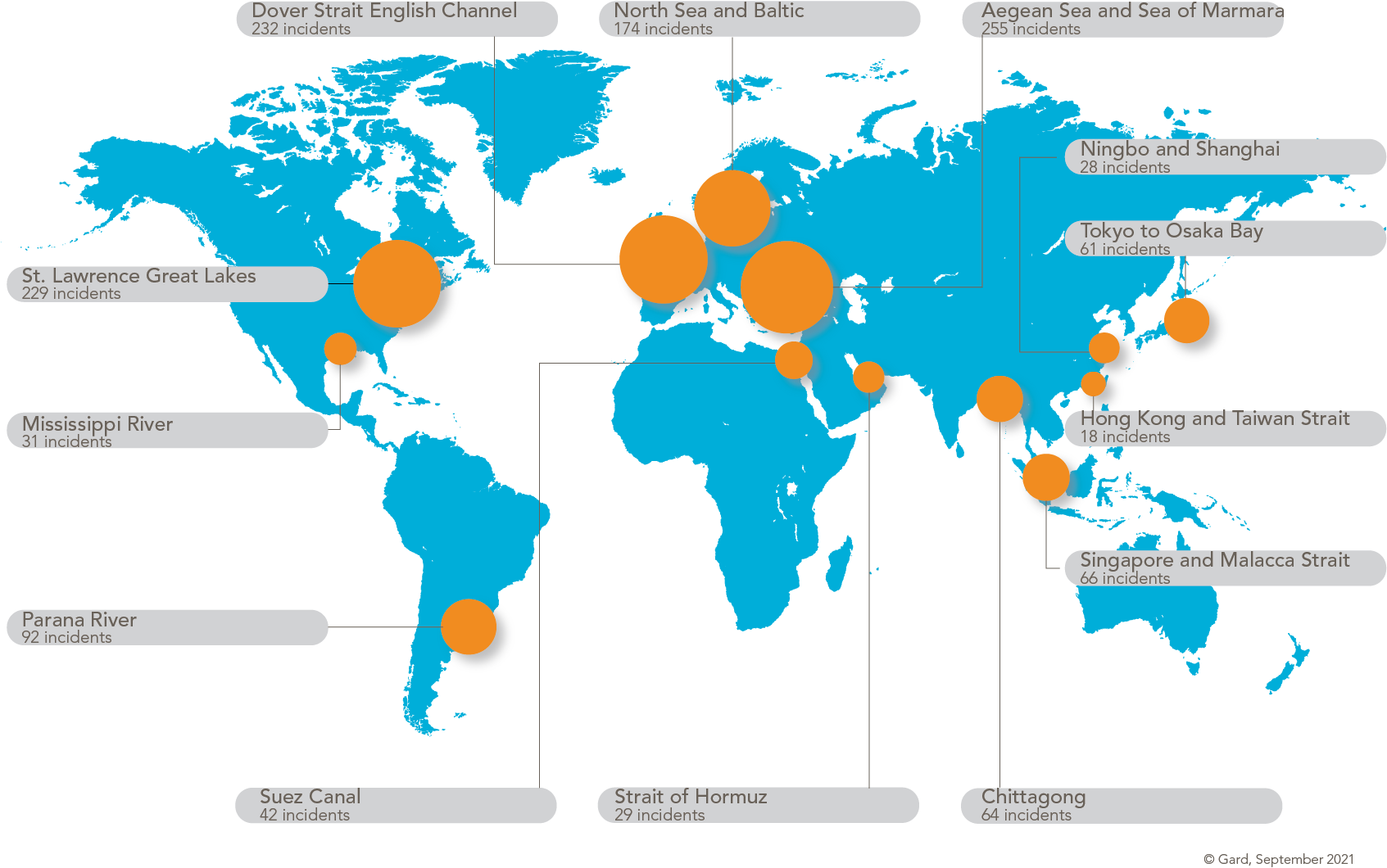
The heat map may not come as a surprise as the areas of high traffic incidents are well known to most operators and mariners. The below map shows all the areas with their respective number of navigational incidents. For the ease of understanding we have named these areas based on the general geographical boundaries defining our area of interest. These names should be used for geographical reference only.
Sources: Lloyd’s List Intelligence Casualties Data 2016-2020
Editors note:
We have only published part of the original article here. Many thanks to Gard AS.
Editors note:
We have only published part of the original article here. Many thanks to Gard AS.

