photos, graphics and article by "The Pilot" Magazine (June 12th, 2019)
On behalf of the Association Members the Technical and Training Committee have been investigating the use of Personal Locator Beacons. This report covers some of our work, along with links to various websites, which members will find useful.
Foreword
Personal Locator Beacons (PLB) and other individual MOB devices have been available for some years now and have evolved to incorporate a variety of different alerting methods and combinations. However, usage of these additional enhancements within UK Pilotage is still in its infancy. Whilst unlikely that a Pilot MOB will go unnoticed, there is a strong chance that the casualty may be incapacitated, therefore the activation method, alongside who and what can track it, is clearly key to a device’s adoption in a district. Reduced operating cost and compact design, as well as the greater battery life of newer products, should make a device a viable addition to a pilot’s safety equipment.
Scope of Use
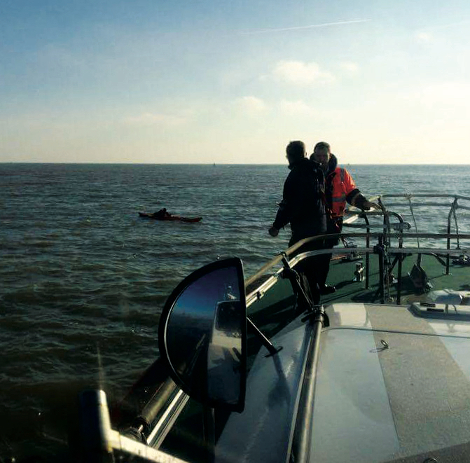
Within harbour areas, the overall responsibility for SAR remains with HM Coastguard UKSAR (see Annex) and whilst likely the first responder remains the on-scene pilot boat, these enhanced MOB systems may save valuable time in relaying the distress and position to the designated services in expediting recovery ashore from the water or pilot boat. They can greatly enhance recovery prospects in reduced visibility and challenging sea conditions. It is therefore incumbent on a district to consider within their recovery plans which device will assist the most, dependent on the size of area and proximity to recovery services. It is also probable that no further equipment expenditure will be needed beyond the individual devices within the port infrastructure.
Signalling Method
It is commonplace for many devices to have dual signalling methods to complement any limitations the prime transmission has. The following methods are widely available for use:
406MHz
PLBs operating on this frequency are for global usage via the COSPAS/ SARSAT satellite network and are classed as a distress signal. They have to be registered with the UK Coastguard, which allocates a unique number and prevents delay in identification. It is free to register and incurs no ongoing cost. An inbuilt
GNSS transmits your position in a ten second data burst, reducing the time for location — without it location could be delayed for up to two hours. The equipment needs a clear view of the sky to operate, generally does not float and, to prevent false activation on a global scale, can only be manually activated.
121.5MHz
This is an analogue two-tone alarm used for homing in on by Rescue services and is often coupled with another alerting feature. Most RNLI craft are equipped to detect the signal, but on a lesser scale now as more modern methods come into service.
AIS
AIS is becoming the mainstream option for sending an alert, though it is not without some limitations as to the scope of detection. At sea level, often the detection range is limited to five miles, but research has highlighted that SAR aircraft from an altitude of 1200 feet can detect a signal in slight seas at up to 19 miles. As such not classed as a distress signal on its own, this method is often coupled with an additional signal method to augment the alert. Similarly, depending on the age and software suite onboard nearby vessels, there is a chance that the AIS alert alone may not activate an ‘alarm’. However, most software will display the received data on secondary displays, giving an enhanced recovery option from a GNSS input and an alert. They have a 2 channel VHF transmission to enable reception on both AIS Class A & B vessels and transmit an ‘impolite AIS protocol’ to interrupt all other transmission slots. This enables detection even in congested traffic areas (see Annex).
DSC
DSC is a VHF Digital Selected Calling transmission used to supplement the primary signal and raise a VHF DSC distress alert on board vessels in the area. DSC may transmit initial position information from GNSS, but not necessarily in detail. It requires an MMSI number to be configured into the device via the manufacturer’s website.
Operational Factor
With any new equipment it is important to ensure that the user is fully conversant with the operating manuals for the device. It is essential to remove safety guards from some devices to enable them to be armed for operation and for these to be replaced on completion to prevent false activation.
Additionally, it should be noted that on activation, many of the newer, compact systems deploy a metal antenna which may need consideration around the use of a spray hood and which could cause injury during recovery. Should the semi-automatic activation method be adopted, it will be secondary to inflation of the lifejacket, which requires a lanyard secured around the bladder. It is recommended that your lifejacket servicer do this, provided he or she is sufficiently experienced so as not to infringe the inflation process. An individual’s device requiring MMSI registration can be applied through Ofcom (online for free) as a Ship’s Portable Licence (see Annex).
Available Systems
The following systems are available for use within the UK. Some are commonly used in a number of districts. From a user perspective many offer long battery lives without the need for annual servicing and with an option of an intrinsically safe variant where needed. In general, across the board, a device can be purchased from around £200 for a service life of five years+.
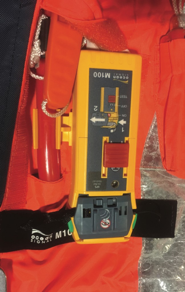
www.oceansignal.com
RescueME MOB1 – AIS/DSC https://bit.ly/2G3Al6p
M100 – AIS/121.5MHz https://bit.ly/2S6aVLBp
RescueME PLB1– PLB/121.5Mhz https://bit.ly/2WicTIg
www.kannadmarine.com
SafeLink R10 SRS. – AIS https://bit.ly/2RLIcfI
www.mcmurdogroup.com
SmartFind S20 – AIS https://bit.ly/2G082Wb
Fastfind220–PLB/121.5MHz. https://bit.ly/2G082Wb
www.acrartex.com AisLinkMOB–AIS/DSC https://bit.ly/2B6OBYB
www.mrtsos.com SeaMarshall AU9 -121.5MHz https://bit.ly/2WiYU4I
SMRT AU10 – AIS/121.5MHz https://bit.ly/2TdjdP5
Rescue Services
HM Coastguard Stations
On a national level the RCC detects PLBs, detailed to the local area for coordinating a response. They don’t have the facility to directionfind for VHF and 121.5MHz but will obviously coordinate any SAR response. It is unlikely that any MOB incident would be in range of a coastguard station for AIS devices, and in any event their equipment does not generate an alarm. VHF DSC may be detected if within range of a Coastguard station. (MGN 324 Appendix IV)
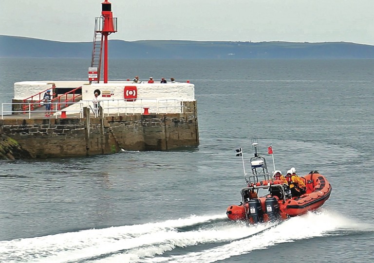
RNLI
The all-weather lifeboats (ALBs) and Atlantic 85 Inshore lifeboats are fitted with VHF direction finding and 121.5MHz and more commonly with AIS capability.
https://bit.ly/2sJX67k
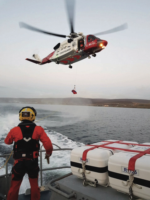
Bristow SAR helicopters
Introduced into service from 2015 around the country, these are modern helicopters equipped with Infrared Thermal Imaging, Night Vision goggles, and direction finding on VHF Ch 16 and 121.5MHz. (For non-PLB districts, keying a carrier on Ch16 on handheld VHF remains an option!). Bristow SAR services are available 24 hours a day, 365 days a year and are able to launch within 15 minutes between 08:00 & 22:00 and 45 minutes between 22:00 & 08:00. These helicopters are commonly fitted with AIS with SAR identifier. https://bit.ly/2FPnaql
Annex
The UK SAR – Strategic Overview of Search and Rescue Version 1 January 2017
https://bit.ly/2DzqbJ4I
Solas V Annex 17 – MCA Guidelines in the use of AIS https://bit.ly/2G3WmBI
COLREGS Annex IV https://bit.ly/2Dxql3j
Ship’s Portable Radio Licence Application Guidelines https://bit.ly/2sHNMRw
MCA guidance on Personal Emergency Radio Devices https://bit.ly/2WkwLKw
Automated Identification Systems https://bit.ly/2FZhjOn
AIS mob versus PLB https://bit.ly/2CPaHyK
Glossary
AIS Automatic Identification System
AIS Class A Fitted to vessels >300GRT on international voyages & >500GRT
AIS Class B Non Class A (and Non SOLAS vessels) – a lower priority and powered signal and less frequently transmitted
COSPAS/SARSAT Search and Rescue Satellites operating on 406MHz EPIRB
GNSS Global Navigation Satellite System such as GPS
MMSI Maritime Mobile Security Identity
RCC Rescue Coordination Centre
PLB Personal Locator Beacon
On behalf of the Association Members the Technical and Training Committee have been investigating the use of Personal Locator Beacons. This report covers some of our work, along with links to various websites, which members will find useful.
Foreword
Personal Locator Beacons (PLB) and other individual MOB devices have been available for some years now and have evolved to incorporate a variety of different alerting methods and combinations. However, usage of these additional enhancements within UK Pilotage is still in its infancy. Whilst unlikely that a Pilot MOB will go unnoticed, there is a strong chance that the casualty may be incapacitated, therefore the activation method, alongside who and what can track it, is clearly key to a device’s adoption in a district. Reduced operating cost and compact design, as well as the greater battery life of newer products, should make a device a viable addition to a pilot’s safety equipment.
Scope of Use
Within harbour areas, the overall responsibility for SAR remains with HM Coastguard UKSAR (see Annex) and whilst likely the first responder remains the on-scene pilot boat, these enhanced MOB systems may save valuable time in relaying the distress and position to the designated services in expediting recovery ashore from the water or pilot boat. They can greatly enhance recovery prospects in reduced visibility and challenging sea conditions. It is therefore incumbent on a district to consider within their recovery plans which device will assist the most, dependent on the size of area and proximity to recovery services. It is also probable that no further equipment expenditure will be needed beyond the individual devices within the port infrastructure.
Signalling Method
It is commonplace for many devices to have dual signalling methods to complement any limitations the prime transmission has. The following methods are widely available for use:
406MHz
PLBs operating on this frequency are for global usage via the COSPAS/ SARSAT satellite network and are classed as a distress signal. They have to be registered with the UK Coastguard, which allocates a unique number and prevents delay in identification. It is free to register and incurs no ongoing cost. An inbuilt
GNSS transmits your position in a ten second data burst, reducing the time for location — without it location could be delayed for up to two hours. The equipment needs a clear view of the sky to operate, generally does not float and, to prevent false activation on a global scale, can only be manually activated.
121.5MHz
This is an analogue two-tone alarm used for homing in on by Rescue services and is often coupled with another alerting feature. Most RNLI craft are equipped to detect the signal, but on a lesser scale now as more modern methods come into service.
AIS
AIS is becoming the mainstream option for sending an alert, though it is not without some limitations as to the scope of detection. At sea level, often the detection range is limited to five miles, but research has highlighted that SAR aircraft from an altitude of 1200 feet can detect a signal in slight seas at up to 19 miles. As such not classed as a distress signal on its own, this method is often coupled with an additional signal method to augment the alert. Similarly, depending on the age and software suite onboard nearby vessels, there is a chance that the AIS alert alone may not activate an ‘alarm’. However, most software will display the received data on secondary displays, giving an enhanced recovery option from a GNSS input and an alert. They have a 2 channel VHF transmission to enable reception on both AIS Class A & B vessels and transmit an ‘impolite AIS protocol’ to interrupt all other transmission slots. This enables detection even in congested traffic areas (see Annex).
DSC
DSC is a VHF Digital Selected Calling transmission used to supplement the primary signal and raise a VHF DSC distress alert on board vessels in the area. DSC may transmit initial position information from GNSS, but not necessarily in detail. It requires an MMSI number to be configured into the device via the manufacturer’s website.
Operational Factor
With any new equipment it is important to ensure that the user is fully conversant with the operating manuals for the device. It is essential to remove safety guards from some devices to enable them to be armed for operation and for these to be replaced on completion to prevent false activation.
Additionally, it should be noted that on activation, many of the newer, compact systems deploy a metal antenna which may need consideration around the use of a spray hood and which could cause injury during recovery. Should the semi-automatic activation method be adopted, it will be secondary to inflation of the lifejacket, which requires a lanyard secured around the bladder. It is recommended that your lifejacket servicer do this, provided he or she is sufficiently experienced so as not to infringe the inflation process. An individual’s device requiring MMSI registration can be applied through Ofcom (online for free) as a Ship’s Portable Licence (see Annex).
Available Systems
The following systems are available for use within the UK. Some are commonly used in a number of districts. From a user perspective many offer long battery lives without the need for annual servicing and with an option of an intrinsically safe variant where needed. In general, across the board, a device can be purchased from around £200 for a service life of five years+.
www.oceansignal.com
RescueME MOB1 – AIS/DSC https://bit.ly/2G3Al6p
M100 – AIS/121.5MHz https://bit.ly/2S6aVLBp
RescueME PLB1– PLB/121.5Mhz https://bit.ly/2WicTIg
www.kannadmarine.com
SafeLink R10 SRS. – AIS https://bit.ly/2RLIcfI
www.mcmurdogroup.com
SmartFind S20 – AIS https://bit.ly/2G082Wb
Fastfind220–PLB/121.5MHz. https://bit.ly/2G082Wb
www.acrartex.com AisLinkMOB–AIS/DSC https://bit.ly/2B6OBYB
www.mrtsos.com SeaMarshall AU9 -121.5MHz https://bit.ly/2WiYU4I
SMRT AU10 – AIS/121.5MHz https://bit.ly/2TdjdP5
Rescue Services
HM Coastguard Stations
On a national level the RCC detects PLBs, detailed to the local area for coordinating a response. They don’t have the facility to directionfind for VHF and 121.5MHz but will obviously coordinate any SAR response. It is unlikely that any MOB incident would be in range of a coastguard station for AIS devices, and in any event their equipment does not generate an alarm. VHF DSC may be detected if within range of a Coastguard station. (MGN 324 Appendix IV)
RNLI
The all-weather lifeboats (ALBs) and Atlantic 85 Inshore lifeboats are fitted with VHF direction finding and 121.5MHz and more commonly with AIS capability.
https://bit.ly/2sJX67k
Bristow SAR helicopters
Introduced into service from 2015 around the country, these are modern helicopters equipped with Infrared Thermal Imaging, Night Vision goggles, and direction finding on VHF Ch 16 and 121.5MHz. (For non-PLB districts, keying a carrier on Ch16 on handheld VHF remains an option!). Bristow SAR services are available 24 hours a day, 365 days a year and are able to launch within 15 minutes between 08:00 & 22:00 and 45 minutes between 22:00 & 08:00. These helicopters are commonly fitted with AIS with SAR identifier. https://bit.ly/2FPnaql
Annex
The UK SAR – Strategic Overview of Search and Rescue Version 1 January 2017
https://bit.ly/2DzqbJ4I
Solas V Annex 17 – MCA Guidelines in the use of AIS https://bit.ly/2G3WmBI
COLREGS Annex IV https://bit.ly/2Dxql3j
Ship’s Portable Radio Licence Application Guidelines https://bit.ly/2sHNMRw
MCA guidance on Personal Emergency Radio Devices https://bit.ly/2WkwLKw
Automated Identification Systems https://bit.ly/2FZhjOn
AIS mob versus PLB https://bit.ly/2CPaHyK
Glossary
AIS Automatic Identification System
AIS Class A Fitted to vessels >300GRT on international voyages & >500GRT
AIS Class B Non Class A (and Non SOLAS vessels) – a lower priority and powered signal and less frequently transmitted
COSPAS/SARSAT Search and Rescue Satellites operating on 406MHz EPIRB
GNSS Global Navigation Satellite System such as GPS
MMSI Maritime Mobile Security Identity
RCC Rescue Coordination Centre
PLB Personal Locator Beacon

